“Hello, World!”
Introducing Amini Lite: An Exciting New Phase
Today we are launching Amini Lite, a lightweight version of the Amini Platform designed to make critical geospatial datapoints on Africa and the Global South quickly and easily accessible to data analysts, developers and growing businesses.

Amini Lite V1 is a deceptively simplified platform, providing a streamlined user experience and access to the incredbile data ingestion, processing and computing power of the Amini infrastructure.
This launch includes a curated list of only the most valuable vegetative indices, and the associated documentation to get you started in the shortest time possible. Whether a novice or geospatial whizz, gain instant access to pre-computed data and smoothly integrate it with your existing workflows via data download (csv) or API.
.png)
You can access the platform here: https://lite.amini.ai
Why Lite, Why Now
Amini Lite is the first step towards our ultimate goal which is to enable the development of a million impactful solutions in and for the Global South, all based on the Amini data platform.
After working with enterprise customers for a few years, we heard the need for a more accessible platform. From builders and analysts who want to create better, more accurate solutions to environmental and business problems. Who want to move fast, iterate, test and use cutting edge tools to create new opportunities for their customers.

This is our first attempt to provide something directly to developers and data analysts, especially those looking to quickly integrate highly technical datasets (e.g., geospatial data from satellite imagery or remote sensing) without the pain of working with specialist geospatial tools.
Amini Lite is a return to our roots. We are developers and engineers who want to build incredible tools for other developers. Our hope for this platform is that we will build and grow together.

What to Expect
Today on Amini Lite you can register an account, buy credits and request data for an area of interest.
First, the platform is usage based meaning you pay only for what you need and nothing more. This gives you the flexibility to scale up and down as you go. If you only have a quick query on the potential location of a reforestation project or want to run more in-depth analysis to provide accurate fertilizer use advice for farmers across an entire county, the platform moves with you.
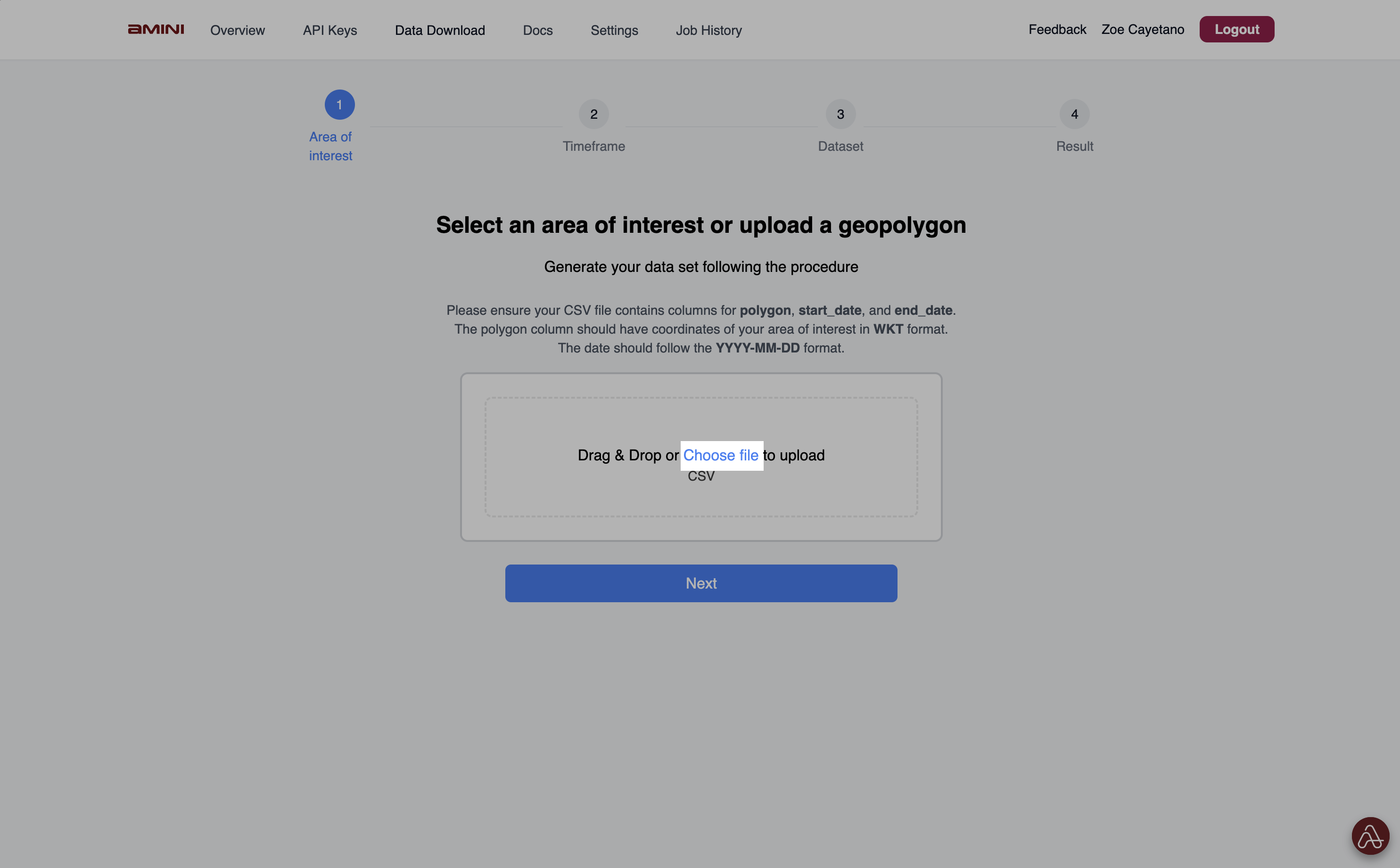
Secondly, Amini Lite is a one stop shop for various data sources. The platform gives you access to data to make life simpler, whether you need it to be granular down to a pixel or aggregated for region-level analysis. We aim to provide richer data for better decision making through the continuously growing data catalog.
Third, in a few clicks, Amini Lite enables you to layer various data points on your area of interest around crop health, water stress and more critical information for environmental and climate analysis. The platform has been designed to be as easy to use as possible to make geospatial analysis faster and easier for more analysts and businesses across the Global South.
.avif)
What Next?
We have a long list of features that will be released incrementally over the next few weeks and months. Expect regular feature updates and growing capabilities on the platform every week.
Some features and capabilities coming soon include
- Amini SDK
- Growing list of unique and relevant datasets from the Amini Data Catalog
- Map-based web application for easy visualization of your interest
- Analytic workflows and code samples to get you started building applications quickly
- AI tools to help you interpret insights
- and so much more...
Additionally, Amini Lite is for you, so our most important feature is the ability to tell us what you need. We will be taking your feedback every step of the way to ensure our vision of co-building a tool that works for developers across the global south is fulfilled.
That is why we created
the Amini Community on Slack and Discord. Our community is an open space to provide feedback, make feature requests, ask questions about geospatial data, access tutorials and more as we co-build. We have some exciting plans for the community so be sure to join and begin interacting with other analysts, researchers, developers and innovators across the Global South.
We look forward to seeing what you think of the platform, learning more about your data needs and providing increasingly valuable features to help you create impactful solutions for people and planet.
-01-min.png)
Get Started
We look forward to seeing what you think of the platform, learning more about your data needs and providing increasingly valuable features to help you create impactful solutions for people and planet.
Please Contact us for access if you'd like to learn more.

Blog


.png)